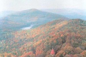
Lavender Mountain and Berry Reservoir
The Berry College Campus consists of 26,000 acres (10,522 hectares) of forest, mountains, and farmlands. It is perhaps the largest college campus in the world. The Berry Ecosystem, if one may call it that, contains a diversity of species and habitats. It is a natural laboratory for ecological research.
The main campus of Berry College lies entirely within the Appalachian Valley and Ridge Province. This physiographic province consists of roughly parallel sandstone ridges, separated by shale or limestone valleys. One such ridge, Lavender Mountain (elevation 1701 feet) bisects the campus, separating the Coosa Valley from Little Texas Valley. On a clear day, one can see the neighboring states of Alabama, Tennessee, and North Carolina from the summit of Lavender Mountain. The Coosa Valley is the southern extension of the Great Appalachian Valley, which extends from Alabama to New York. The lowest elevation on campus is 565 feet, in the Coosa Valley, where the campus borders the Oostanaula River. The elevational diversity (1137 feet vertical displacement) contributes to the high biological diversity of the campus.
Canis latrans, photographed by Justin Edge. For audio of a pack howl, click here:
.
Berry College campus is in the Gulf Slope section of the Oak-Hickory-Pine Forest Region (Kuchler 1964). This is a region dominated by oaks (white, black, red, chestnut), hickories (pignut, shagbark), and pines (loblolly, longleaf, shortleaf, Virginia)(Braun 1950). Little of the original forest remains; the forest on Berry Campus is second growth, and much of it is managed for loblolly pine.
The following species lists have been collected from a variety of sources, including published material, Georgia Game and Fish Division files, two dissertations (Jones 1940, Lipps 1966), and collections by Berry College faculty and students (including John Graham’s Biological Diversitycourse). This page will continue to grow.
The Forest at the Old Mill
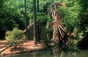
The Old Mill on Berry College’s Mountain Campus lies in a narrow valley on the south-facing slope of Lavender Mountain. The Old Mill Forest on the ridge overlooking the mill is primarily oak and hickory, with pines on the drier slopes, and dogwood, sourwood, and cucumber magnolia in the understory. There is a beautiful stand of longleaf pines here (Birkhead and McGuire1998). This is one of the last remaining stands of longleaf pine in the Valley and Ridge Province (Andrews 1917, Ware et al. 1993). Longleaf pine is a fire-adapted species, and in southern Georgia is associated with the endangered red-cockaded woodpecker. To reach the longleaf pines from the Old Mill, take the foot trail up the hillside; the beginning of the trail is near the dam (lower left-hand corner of the accompanying photgraph).
The moist corridor along the stream is primarily maple, elm, and beech, with mountain laurel in the understory. The Old Mill Pond and Stream have a variety of salamanders, fish, and aquatic arthropods.
Old Mill, Mountain Campus
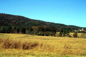
The Old Field near the mill is in the early stages of secondary succession. It was abandoned several years ago, and is being invaded by various grasses, herbs, shrubs, and trees. To reach the old field, take the trail that begins near the far gravel parking lot. Keep to the left until the trail crosses a stream bed that is often dry. Just past the stream crossing, a side trail on the right will take you to the old field. This field gives a beautiful overview of the Coosa Valley.
Lavender Mountain and Adjoining Fields. The Old Mill area is on the upper left.
Photo taken from Possum Trot Road.
The Forest at Victory Lake
Victory Lake lies in the flatwoods of the Coosa Valley. The Victory Lake Forest is very different from the forest at the Old Mill. The dominant trees are oaks (white, red, black) and pines (loblolly), with dogwood and redbud in the understory. At the upper end of the lake, where Big Dry Creek enters, there is a stand of planted bald-cypress. The swamp here also contains red maple and black gum. A hiking trail passes around the lake. See Pat Tomlinson’s Victory Lake Trail page for a discussion of the habitat and plants.
Moon Woods
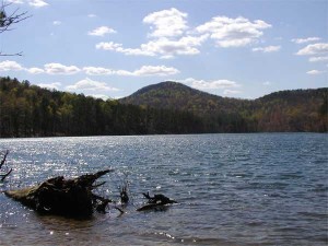
Berry Reservoir
Berry Reservoir supplies water to the entire Berry College community. It is also one of the most beautiful places on campus, and it is the home of the unusual freshwater jellyfish Craspedacusta sowerbyi. The forests on the ridges surrounding the reservoir are dominated by chestnut oak, and loblolly and Virginia pine. The highest point on campus (1701 feet) can also be seen in the photograph.
References
Andrews, E. F. 1917. Agency of fire in propagation of longleaf pines. Botanical Gazette 64: 497-508.
Birkhead, R. and J. P. McGuire.1998. Lavender Mountain–the forgotten longleaf pine of Georgia. Pages 59-61 in Proceedings of the 2nd Longleaf Alliance Conference. Longleaf Alliance Report No. 4.
Braun, E. L. 1950. Deciduous Forests of Eastern North America. Hafner, New York.
Jones, H. C. 1940. Plant ecology of the Berry Schools property, Floyd County, Georgia. Ph.D Dissertation, George Peabody College, Nashville.
Kuchler, A. W. 1964. Potential natural vegetation of the conterminous United States (map and illustrated manual). American Geographical Society, New York.
Lipps, E. L. 1966. Plant communities of a portion of Floyd County, Georgia–especially the Marshall Forest. Ph.D. Dissertation, University of Tennessee, Knoxville.
Ware, S., C. Frost, and P. D. Doerr. 1993. Southern mixed hardwood forest: the former longleaf pine forest. Pages 447-493 In W. H. Martin, S. G. Boyce, and A. C. Echternacht (eds.) Biodiversity of the Southern United States: Lowland Terrestrial Communities. Wiley, New York.
Last Updated 10 August 2015


